
I often get to hear from my fellow pilots from more mountainous regions, how they can’t get their head around the flatland flying. Some argue that it’s so easy, you just go with the wind from cloud to cloud and others think it must be some kind of black magic to be able to fly above a pancake with no obvious trigger points. I guess both sides have a point but also reflect the lack of understanding towards the beauty and true challenge that flatlands offer to us paragliders. I try to open a little bit how it’s done and what treasures of wisdom there are hidden in the flatlands for you mountain goats, too, by analyzing a nice flight last week.
Understanding the weather
I have been analyzing the weather forecasts on daily basis for my outdoor activities for almost three decades. I’m not an expert meteorologist by no means but I guess I’m starting to have a vague idea of the day and its potential beforehand based on different data sources. Understanding the dynamics of the big picture and frontal systems is the key for really long flights in the flats.
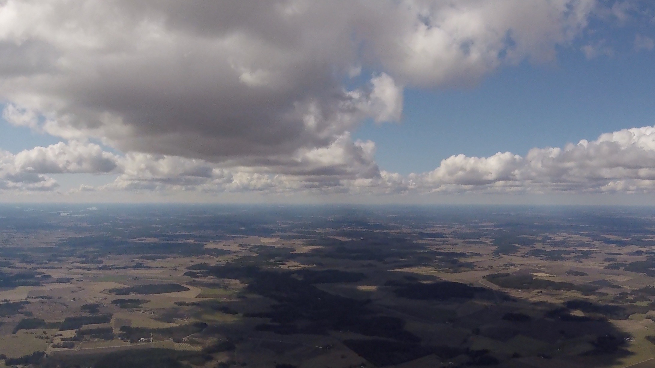
We had a high-pressure system over Finland for a few days this week with reasonably high base and classic pre-frontal conditions coming with strong thermals and high windspeed for a day or two. End of May and early June the lapse rate is usually quite good because of the cold nights and strong sunshine. For me there is two kinds of “good paragliding”. Usually the post-frontal, southern wind days offer smooth, nice climbs with high enough base for easy hundred plus km flights. That’s when there are smiles and joyful chatter on the airfield before the day gets going.
Then there is the other end of the spectrum, which I also like very much but it needs a totally different mindset. We call it “full contact paragliding” and you can experience it in some pre-frontal days. The mood is then quite different in the towing field, it’s like young men going to war. Strong north-west or rare pre-frontal east winds offer a turbulent ride with strong, sharp-edged thermals and scary sinks in between. The beautiful thing in Finland is the shape of our country. If you have east wind, you can start flying across southern Finland and then reach the convergence that forms when East wind hits the sea breeze from south west and continue your flight straight up to north. That was exactly what we saw in the forecast couple of days ago. It opens up a possibility for an epic flight. My guess is that we will see the first 400 km or even 500 km flight in Finland just in these conditions someday.
Airspace
One problem with these long flight plans is that it needs careful planning and often contacting towers beforehand. For me personally, that adds some mental pressure. I know it’s irrational and it is my next challenge to tackle. Having made a flight plan with towers a few times and not succeeding to execute it makes it easy to just give up and to not make a plan beforehand or even worse, to not look the operating hours or radio frequencies of the towers at all. I only had had a glimpse to restricted areas on a possible route but not paid enough attention to towers longer ahead and that cost me at least 50 km or even more on this flight.
Flying the flats
When it’s rough and strong, everybody stays up. It’s more of a question of keeping it all together and the wing open. The long flights however need much more tools in your toolbox. Often you start with weak thermals and strong wind. It basically means that after releasing from the tow you drift sometimes several if not tens of kilometers very low in a small bubble before it triggers, usually when it hits a cold lake.
Then you need the nerves to start climbing over a big forest or a lake in a weak and narrow bubble, knowing that you won’t possibly make it to the downwind shore if you lose the core and there will be only forest to land anyway. And pushing into the wind is just a pipedream with nothing less than a two liner.
Is it risky? You need to know your abilities, feel the air and trust your wing a lot, let’s put it that way. When the day gets going, the few strongest hours need very active flying with good wing control skills. And you need to be above your game to be able to concentrate on the strategic side of flying and not only keeping the nose open. That should come from the spinal cord with not much thinking. The day usually starts to weaken at 4 pm. but can offer smooth climbs long after that. Last two to three hours you should be able to fly with the wind and not fight against it. If you make a mistake on your route choice hours before, it is too late to correct now. The soft skills play the part especially this time of the day.
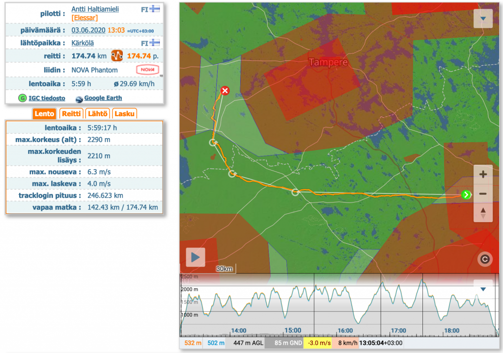
My 175 km-flight on June 6, 2020
I saw the Day coming but couldn’t cancel a meeting in the morning, so that was a bummer to start with. I knew I would be arriving at the towing field at least two hours later than optimal but I reckoned there was still a 200 km day ahead for me to take if I made no mistakes.
When I arrived to towing field my miserable former flight student stood there waiting for someone to tow him. I decided to collect good karma and towed him a few times. When I finally got to the air with my PHANTOM, I was rewarded with a screamer first thermal going straight up from a dust devil taking me straight to base. Cloud hopping and taking a few non-event collapses when exiting strong cores before base made me remember Steve Ham’s soothing voice from Piedrahita skies and I realized how these two totally different landscapes sometimes share the same nature of the air. The only difference is, that landing possibilities are almost nonexistent for a big part of the flight here in Finland.
Or maybe that is a bit of an overstatement. Of course, you can land where ever you want. But by unlandable terrain I mean places where I don’t want to stuff my glider under any circumstances if I don’t have to. That includes the small fields inside the thick forests because of the turbulence on a treeline and dealing with likely collapses low. Been there and done that one time too many already.
The plan went as thought beforehand and after the first 100 km and some km’s straight line I felt the sea breeze forming and saw the thicker clouds in north and ahead. A 90 degrees change to direction was needed because of the airspaces.
If I only knew they were not active today… I managed to stay in a narrow corridor between the two usually busy airports with sealing restriction 300m below the cloudbase in sidewind for quite some time, but the evident was ahead. Late start combined with the fact that I was still maybe 20 km off the strongest convergence line caused an early landing after six hours in the air. Still, a good flight and a proof for myself that we have such a big potential still waiting us here in northern flatlands.
Cheers from Finland, Antti
Stefan Lauth
Jun 5, 2020 -
Good reading…thanks Antti for sharing your experience & knowledge!
Tobias Ehrmann
Jun 8, 2020 -
Great flight, nice article. Thank you for posting this story!
Brockton
Apr 3, 2021 -
Thanks for sharing. Awesome article!