
Last weekend 3 Nova Team Pilots competed in the 2012 edition of the Crossalps, a hiking and paragliding competition with the objective to go as far away AND back in 33 hours; with the emphasis on having fun whilst trying. Till Gottbrath, Vera Polaschegg and I arrived at the pasta party on the Friday night to meet the other competitors and go through safety and weather briefings.
Till and Vera will have different accounts of the race, but from my viewpoint it went roughly like this:
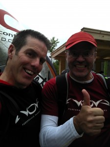
Steve & Till just before the start
07:30 Sat morning – Till and I arrive and with 5 minutes to the start when we realise that our Garmin GPS’s are not routing correctly to the first take off point at Laubenstein. We later realise that a last minute download of the devices the previous night has reset some of the ‘hiking’ routing functions. At exactly 08:00 the gun signals the start and the field splits in all directions, leaving me wondering if we have made the right move to go East (I was originally planning to go South, but the weather seemed to point towards the East for success).
08:10 I arrived first at the small launch site above Aschau, and started to get my gear out as the rest of the field were walking up the slope. With my ION2 wing out of the bag and about to connect it to the harness, the woman farmer appeared screaming and shouting that none of us could fly as it was a nature zone and we would frighten her cows (I think one of the German speaking pilots suggested she may be doing a better job of scaring her stock than we ever could, which only made her shout louder). This meant a repack followed by a walk down to Aschau instead of the planned glide.
11:00 After walking direct up the ski slopes under the Kampenwand Mountain it was obvious that cloudbase was pretty low and flying from the top not possible until later in the afternoon. I looked at a possible launch with a couple of others, but decided that launching into cloud was likely to end in trouble so I moved on. 20 minutes later, I could hear whoops and shouts from the 2 pilots who had launched; I went back the 1km to the same launch just under the cloudbase. After an all too short flight with no lift, I landed on a forest track with the tips of the wing missing the trees either side by a metre or so; good job I’d chosen a small ION2 wing :)
14:00 After a short walk around the front of the Kleinstaffen mountain, I arrived at the Hochplattern launch with the hope of a glide across the Grassau valley. Unfortunately, there was a backwind that I had to sit out for 20 minutes to be sure to clear the line of trees in front of launch that looked like a line of soldiers. From here I managed to glide across to Staudach, landing right next to the bridge across the Achen river.
15:30 My next start point was either going to be the mountains of Hochgern or Hochfelln, I decided that Hochgern was closer and would allow a guaranteed flight as the weather was really improving. This is where my plans started to unravel; the GPS and map led me up a track and path that came to a dead end rather than the track that would take me up to Hochgern. I was now stuck in a maze of trees. Realising I only had the option to go back down the 300m that I had just climbed, the plan changed to head for Hochfelln. The timing would get me to the top of this 1671m mountain by 20:30 – leaving enough time to fly before the 21:10 night flying curfew. The route turned out to be longer and I lost lots of altitude, which I then had to regain and despite pushing hard I reached the base of Hochfelln at 20:20 (too late to get up it and fly to Rupolding as planned). Knowing that I had to fly to meet the 20% flying rule, I tried to find a launch to allow me to get to Bergen, but the hills were covered in trees so no luck. Finally, the forecast for the next day suggested a Foehn wind would set up, making flying unlikely; I still needed to fly today. I decided to go up Hochfelln and sleep there hoping for an early morning flight to Rupolding.
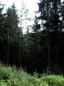
This is what a dead-ended path looks like, damn……
21:30 – I got to the top of Hochfelln and slept in the doorway of the little church that is perched on the top; snugly wrapped in the wing. The night started silent and still, but through the night the wind increased leaving me in dread of a long walk down the mountain in the morning. I could not launch until 05:18, so I was stood fully ready to go at 05:00 watching the minutes tick away on my GPS, as the wind strength increased. I launched at 05:19 and decided to fly to the North for safety, instead of my original plan to fly down the East ridge to a very likely windy Rupolding valley. The flight was not too unpleasant in the air until it came to landing when I had to use the full bar of the ION2 for the last 100m to the ground. Safely down, I quietly sneaked away from the field I had landed in, fearing another angry woman farmer, to pack up alongside the road.
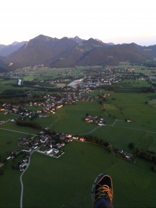
Just before landing on Sunday morning at dawn
05:45 Sunday – Having now already flown back West towards Hochries, I knew that I was going to be back too early. The walk back was mainly on flat tarmac or gravel paths, both of which heated up through the day making the soles of my feet complain a little. On the way back I was attacked by a big viscous dog, nearly fell through a rotten wood bridge over a river and got my carbon walking pole so stuck in the cobbled pavement that I feared I was going to have to leave it there !
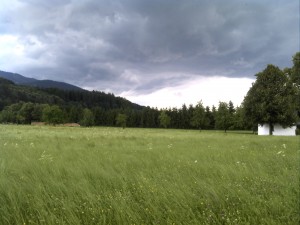
It really wasn’t flyable on Sunday afternoon!
13:30 – I arrived back at Hochries to a fairly deserted finish line with just a couple of other weary competitors recovering after their own ordeal. Over the next few hours I replaced the calories that I had burned during the race, mainly in the form of cakes that were being served.
17:00 – The race finished and most of the field had returned from whichever direction they had headed back from, all had varying degrees of pain showing from the way they walked across the finishing line.
Overall, I was a little disappointed with my race, finishing 22nd, but I still had a huge smile remembering the sunrise flight from Hochfeln earlier that morning. Congratulations to Vera (ION2) for finishing 2nd in the Womens category and for Till (MENTOR2) finishing 11th in the Mens, both as a result of huge, brave efforts and lots of hiking. The race organisers had a priority of making this event fun to compete in; well they achieved that in a big way and for sure I will be applying again in 2013 and if you have a desire to see how far you and your wing can travel in any conditions, suggest you do the same !
Find out more about the event at www.Crossalps.com
Till
Jul 16, 2012 -
Hi Steve,
it was pleasure to have you here and I am pleased that you enjoyed it so much.
As one might guess, I also enjoyed (otherwise I wouldn’t have patricipated 4 times already)
I will add my report as soon as I have sorted out my stuff from OutDoor show).
Cheers
Till